- Philadelphia
Canoe Club
- Pennsylvania
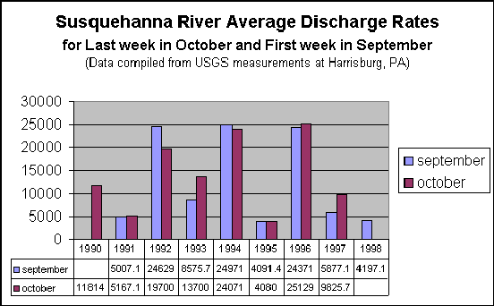
Current Streamflow Conditions
- ACA - American Canoe
Association National Web Site - Membership
organization.
- American Rivers - National conservation
organization dedicated to protecting America's
rivers.
- American Whitewater - American Whitewater
Web Site - Orgs and members - Access &
Conservation.
- Canoe
Camping - Top 40 U.S. Trips - Descriptions
(with pictures and links) of over 40 of the best
canoe camping rivers in the U.S. where you can
enjoy a float trip of a week or more!
- Paddling.net
- PA Outfitters - Canoeing and Kayaking
Guides, Outfitters and Rentals in Pennsylvania
- Outdoor
Resources Online - Resorces for hiking,
biking, backpacking, etc.
- Canoe
and Kayak Ring - Seems like a nice enough
place. They have a pretty big list of members.
Supposably there is a standard necessary for
entry.
- National
Wild & Scenic Rivers System - Home Page
for US National Wild & Scenic Rivers. Wild
& Scenic Rivers are similar to National
Parks, but do not enjoy the same level of
funding. If you would like a better explanation,
the National Park Service has a FAQ
page that explains what a National Wild and
Scenic River is.
- National
Park Maps - This site provides access to
downloadable versions of National Park Service
maps for many National Parks in pdf and high
resolution formats.
- If you need gear you're going to need a place to
get it. REI has
tons of stuff for paddling, and it's all
available for online shopping. If you need
outdoor gear REI will almost definitely have the
item you want. If you want to pay a little less, Dick's Sporting
Goods has a pretty good selection.
Unfortunately Dick's Sporting Goods did not buy www.dicks.com .
That url hosts a completely different site (as I
found out when I was looking for the sporting
goods site). The following are links to dry bags
that I'm considering for this year's trip: REI Drygear Super Sack
- Extra Large 3200 ci, $23, REI Drygear Riverpack
- 3.8 6200 ci, $50, Seal
Line Baja Dry Bag 1900
ci, $15, Seal
Line Baja Dry Bag 3300
ci, $22. Some other good places to get gear are Campmor
, and Eastern
Mountain Sports .
|